Maps, Atlases and Globes
Maps, Atlases and Globes
Exhibited works
-
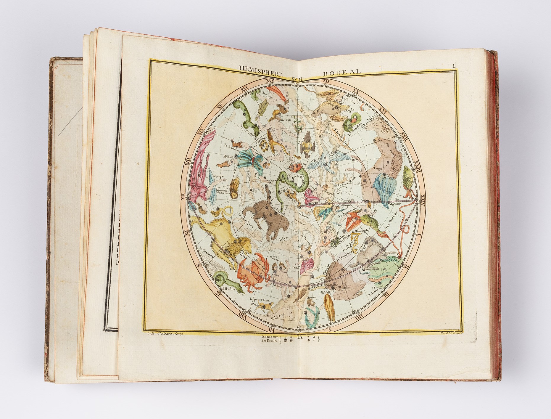
John Flamsteed (author)
England, 1646-1719
Jean Nicolas Fortin (editor)
France, 1750-1831Atlas Céleste de Flamstéed, 1776
A Paris: Chez F.G. Deschamps, Libraire, rue S. Jacques, aux Associés
[Chez] l’Auteur, rue de la Harpe, près celle du Foin., M. DCC. LXXVI.Rare Books Collection
Purchased through the Ivy M. Pendlebury Bequest in memory of Gerard Frederic Pendlebury, 2022John Flamsteed was the first English Astronomer Royal of England, appointed by Charles II (1630-1685) in 1675 following the establishment of the Royal Observatory at Greenwich. Flamsteed was tasked with compiling a new star catalogue, and using the Observatory’s telescopes began gathering data on nearly 3000 stars observable from Greenwich. The product of his research, Atlas coelestis, was the most comprehensive and accurate catalogue of its kind at the time of publication in 1729.
The rare hand-coloured issue on display here is the first French edition of this work, Atlas céleste de Flamstéed, edited and updated by publisher and instrument maker Jean Nicolas Fortin. Newly engraved at about one-third the scale of the English edition, Fortin’s volume was more affordable and easier to use.
-

Georg Braun (editor)
Germany (Cologne, Holy Roman Empire), c. 1541-1622
Frans Hogenburg (engraver)
Belgium (Mechelen, Duchy of Burgundy), c. 1539-1590Byzantium nunc Constantinopolis, c. 1572-1618
Hand-coloured engraving
Second state
Civitates Orbis Terrarum, c. 1572-1618
Coloniae Agrippinae: apud Petrum à Brachel, sumptibus auctorumRare and Historical Maps Collection
Donated by Ronald and Pamela Walker, 2023Civitates Orbis Terrarum, from which this map was cut, was the first atlas to depict the cities of the world (or at least those known to Europe); it was one of the most important publications of the late sixteenth century, and remains a fascinating demonstration of the intersections between art, cartography and political power. Its city views are remarkably accurate, with major features rendered from in-situ drawings. Much attention is given to depicting contextual topographic, industrial, and political details, as well as to artistic effect. This view of Ottoman-ruled Constantinople (now Istanbul) is a particularly strong example: the Hagia Sophia, Topkapı Palace, Süleymaniye Mosque and Hippodrome are all clearly visible, as are the city fortifications and shipyards.
Just as significant is the title, Byzantium nunc Constantinopolis [Constantinople was Byzantium]. During the sixteenth century, the Ottoman Empire’s territories extended almost as far west as Venice. Its military and economic power, and its rulers’ claim of descent from imperial Rome, were particularly grating for their rivals, the Hapsburgs of the Holy Roman Empire. It is probable that this map was part of a propagandist campaign to diminish public perceptions of Ottoman influence and legitimacy by suggesting their power, like their city, was derived from the much older Byzantine Empire.
-
William Johnston
Scotland, 1802-1888
Alexander Keith Johnston
Scotland, 1804-1871Johnston’s Twelve Inch Celestial Globe, c. 1864
Hand-coloured engraving over papier mache core, lacquer, brass, wood
W & AK Johnston, EdinburghRare Books Collection
Purchased through the Ivy M. Pendlebury Bequest in memory of Gerard Frederic Pendlebury, 2022Celestial globes are intended as spherical representations of the skies, whereas terrestrial globes show the geography of the earth. Celestial globes date back to the ancient Greeks; and later Islamic cartographers, from the 8th to the 14th century CE, were known for their highly accurate globes depicting stars and celestial bodies. The celestial globe on display was created by the firm of W. & A.K. Johston, an important British maker of atlases and globes operating in the late 19th and early 20th centuries.
The Scottish born brothers Willam Johnston (1802-1888) and Alexander Keith Johnston (1804-1871) originally learnt their trade under Scottish globe maker and publisher James Kirkwood, later founding their own business in Edinburgh’s New Town in 1826. Their maps, atlases, and globes, renowned for their accuracy, were highly prized: they were honoured with a royal appointment from King William IV in 1834, and their globes were awarded a number of medals at the Great Exhibition in London in 1851. Their ’12 inch globe’, created in 1864, is a fine example of their craft, demonstrating both scientific precision and aesthetic beauty.