Orientaliora Indiarum Orientalium by Frederik de Wit
Download
after Pieter Goos (Dutch, 1616–1675)
Orientaliora Indiarum Orientalium ... (Eastern parts of the East Indies ...)
from Atlas: Tabulae maritimae ofte Zee-Kaarten
Amsterdam: Frederik de Wit, c. 1675–80
hand-coloured engraving
43.9 × 54.0 cm (image)
47.7 × 54.6 cm (plate)
51.1 × 60.2 cm (sheet)
Purchased 2014
Map Collection
http://hdl.handle.net/11343/113762

Map Collection, University of Melbourne Library
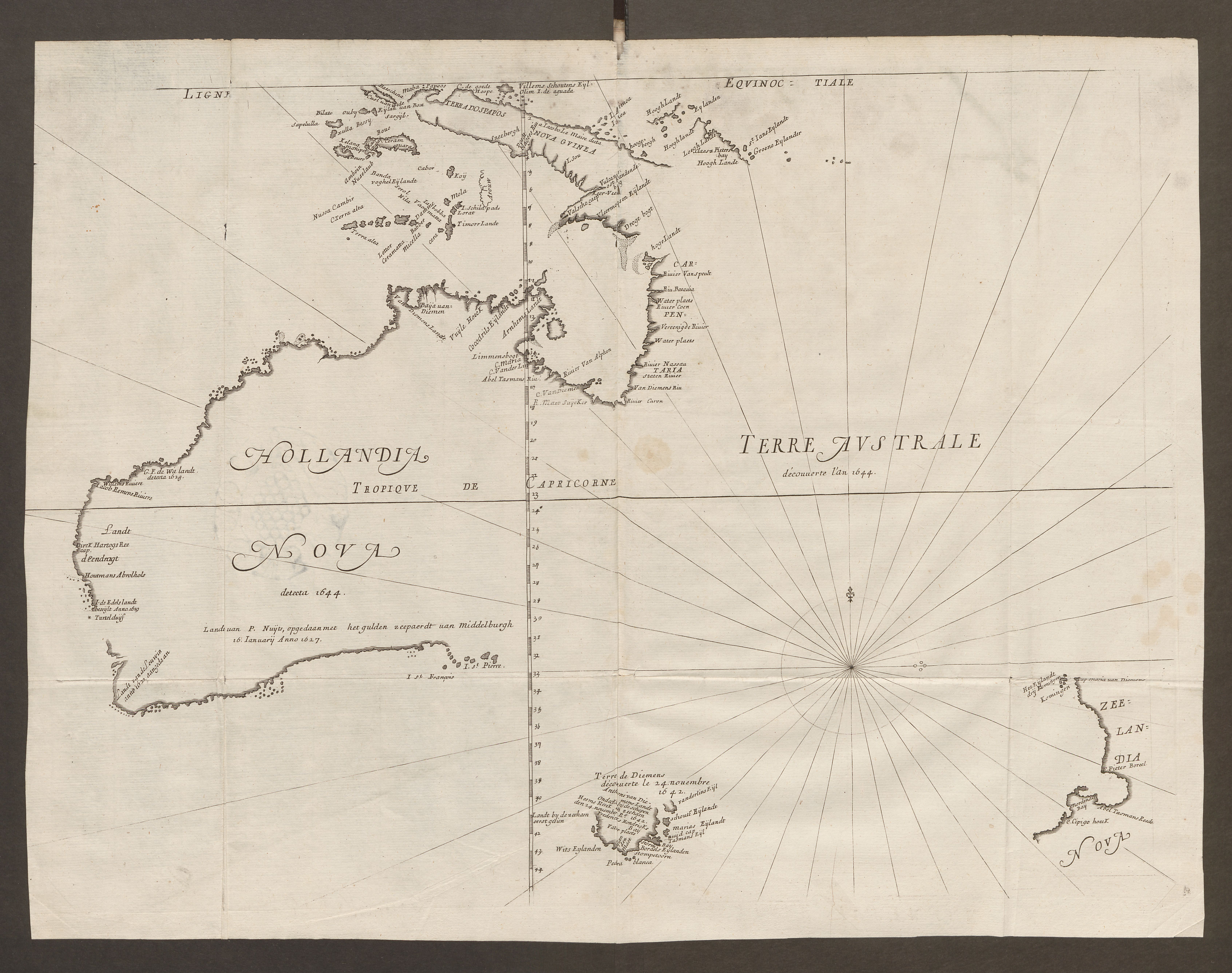
This Dutch maritime chart shows areas of Australia, China and the ‘East Indies’ (parts of India, Laos, Taiwan, Korea, Japan, the Philippines and Indonesia). It presents an unusual orientation, with north to the left of the sheet. It is based on Pieter Goos’ chart of 1666 (Paskaerte Zynde t’Oosterdeel Van Oost Indien). The Dutch East India Company (Vereenigde Oost-Indische Compagnie) was established in 1602 and had its port in Batavia (present-day Jakarta). This powerful company enjoyed great wealth derived from the spice trade of the Maluku Islands. The Dutch were eager to explore the lands of the Indian Ocean, with a view to making money, and it was this ambition that brought them to Australia.
Dutch landings and charting led the Great South Land or Terra Australis to be named ‘New Holland’ in the 17th century. The de Wit chart reflects coastlines recorded by the Dutch, such as in charts made by Abel Tasman (1603–1659) on his voyages of exploration in 1642 and 1644, during which he charted sections of Australia (including Tasmania) and New Zealand. Unlike the Portuguese and Spanish, the Dutch were unaware of the strait separating Cape York from New Guinea and showed these two countries joined. The rhumb lines and compass points on this chart indicate that it served a practical purpose in plotting a navigational course.
Teaching ideas
The University of Melbourne’s curriculum is rich and varied, and changes from year to year. For more teaching ideas, contact a collection manager.
Mapping Environments
Study historic sea charts to understand methods of determining position. Compare charts to map projections. How did cartography in paper maps develop? Visit the Map Collection to view a variety of examples at first hand.
Imaging the Environment
Describe the characteristics of different landmass-imaging techniques in historic maps. Consider the role of decoration and colour, and the commercial imperatives of map production.
Generating the Wealth of Nations
Explain the importance of the Dutch East India Company in European colonial expansion and the rise of trading economies. Find evidence in Dutch maps to support your argument.
Migration and Development
In maps at the university, what evidence can you find of circumstances that can lead to human mobility?
Law of the Sea
The law of the sea relates to the allocation of jurisdiction and peaceful uses of the seas and oceans, the equitable and efficient use of marine resources, and the study, protection and preservation of the marine environment. What precedents in history have seen this law develop? Are they represented in maps?
Age of Empires
Analyse maps as primary source material in writing about the past. What can they reveal about the Age of Discovery, the Enlightenment and colonial expansion?
Encounters with Writing
Use objects such as maps as memory and creative triggers, to initiate and develop detailed knowledge in self-initiated creative writing projects.
Knowledge, Learning and Culture
Visit the Map Collection and, working in groups, examine maps and discuss how they transmit knowledge.
Intersecting objects
-
Frederik de Wit (Dutch, 1630–1706)
Magnum Mare del Zur cum insula California De Groote Zuyd-Zee en’t eylandt California (Great Sea of the south with the island of California)
from Orbis Maritimus ofte Zee Atlas
Amsterdam: Frederik de Wit, c. 1675
hand-coloured engraving
50.0 × 56.0 cm (image)
53.0 × 62.0 cm (sheet)
Purchased 2014
Map Collection
University of Melbourne Library
http://hdl.handle.net/11343/113763 -
Melchisédech Thévenot (French, c. 1620–1692)
Hollandia Nova / Terre Australe (New Holland / South Land)
from Relations de divers voyages curieux ... (Account of diverse and curious voyages ...)
Paris: Jacques Langlois, 1663–72
Rare Books Collection
University of Melbourne Library
To learn more, visit the websites of the Map Collection and the Rare Books Collection.
Further reading
University of Melbourne Library, Plotting the island: Dreams, discovery and disaster (forthcoming, 2017).
J.R. van Diessen et al. (eds), Grote atlas van de Verenigde Oost-Indische Compagnie (Comprehensive atlas of the Dutch United East India Company) (7 vols), Voorburg: Atlas Maior, 2006–10.
National Library of Australia, Mapping our world: Terra Incognita to Australia, Canberra: National Library of Australia, 2013.
University of Melbourne Library, The Pacific in maps: An exhibition from the Map Section, University of Melbourne Library, 1996.